A Fire Diary
George Gray
Monday, September 3, 2007 Passing through Watsonville, a small fire appeared to be burning at Mount Madonna, but as I drove north, the plume moved north too, now appearing to be a medium-sized fire west of Gilroy. As I drove, that plume continued to move north, and my best guess was a large fire east of Gilroy, maybe Coe.
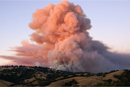
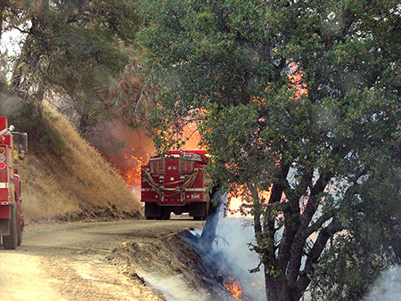
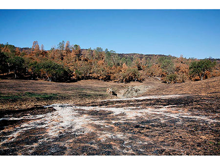
Smoke Billows over Pine Ridge on Monday afternoon
The last guess was right. At home was an email from Bob Patrie with a photograph from Mount Hamilton of a fire which started mid-day on private land on the west end of Blue Ridge. The fire had already run half the length of Blue Ridge, and the smoke column continued to build. A Henry Coe SP neighbor was burning some garbage in a barrel, a burned line of fine fuel led to some brush, and the fire quickly spread east. Ranger Cameron Bowers had gotten there first, picked up the neighbor, and drove her to safety down Hobbs Road.
CAL FIRE was quick to arrive, and with some muscle. Several bulldozers, a dozen fire engines, and some hand crews went directly to Blue Ridge, and more equipment staged at Coe Headquarters. Local Battalion Chief Derek Witmer, familiar with the Henry Coe Wildfire Plan, was the Incident Commander working from Coe Headquarters. During the day, they managed to hold the fire to the north of Blue Ridge Road except at the point near its eastern end where it takes a sharp turn north. There, the fire spread across the road and began to back down to Poverty Flat. On that first day, fuel along roads was bulldozed away from the roads, some ½-acre safe zones were bulldozed, and a hundred burning or burned oaks along Blue Ridge Road were cut down to prevent fire brands from blowing south across the road.
Jeff Frey gave Santa Cruz the call to respond, and Tim Hyland, Chris Spohrer, and I drove over, arriving about dark. The glow from the hills was obvious from the valley.
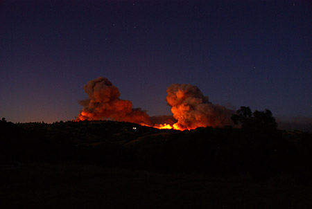
The glow from the hills was obvious from the valley
Supervising Ranger Stuart Organo was with the Incident Commander. An un-nerving glow emanated from the end of Manzanita Point. It did not seem like a good idea to drive down the steep, narrow road to Poverty Flat, but equipment continued to head down.
Ecologist Amy Palkovic was with CAL FIRE at the toe of Blue Ridge, tracking down a backpacker at China Hole. A helicopter circled in the dark, but could not find the spot. The call went to Bob Patrie to get coordinates for China Hole. Within a half hour, the helicopter found the hiker with its light, gave him instructions with its loudspeaker to walk to a point, and he was driven away. He was pretty bold to hold his ground in the path of an intense wildfire. CAL FIRE was reporting flames 400 feet high.
At 11:00 p.m., Incident Command was to be moved to CAL FIRE, Morgan Hill, then to Christmas Hill Park in Gilroy. Coe Headquarters was considered threatened by the fire, especially with eastern winds predicted in two days. Some of the more priceless items from the Visitor Center were evacuated.
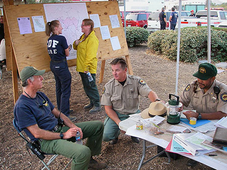
Incident Command Center at Christmas Hill Park
The Morgan Hill meeting marked the change in command. A box of hats was broken open, and the 35 persons assembled from throughout California donned a red ball cap, designating them as 'Team 2'. Large incidents require this level of overhead. Local Battalion Chief Witmer briefed the group, and the stage was set for the next 10 days.
A film crew from National Geographic was present that night, filming the sequence of events and interactions of a wildfire from its inception, for a television program called 'Inside - Operation Wildfire'. They would be present for the duration of the wildfire.
Comparisons with the 1961 Bollinger Ridge fire were made. Some predicted a week of work. I felt that the next major hurdle was the East Fork of Coyote Creek. It is fairly wide and sheltered from the wind. If the East Fork held, everything could be wrapped up in a few days. Chris, Tim, and I slept at Christmas Hill Park.
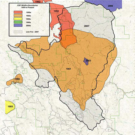
The extent of 1961 Bollinger Fire is in shown in orange, and the extent of the 2007 Lick Fire is shown in gray,
Tuesday, September 4. The routine of two meetings a day began, the briefing at 6:30 a.m. and the planning meeting at 5:00 p.m. The plan for the day was direct attack, and most of the equipment and personnel had worked the night. More equipment began to trickle in to reach the requested 30 bulldozers, 20 fire crews, and over 100 engines.
Fire engines head into the fire
Chris and Tim went out on separate Divisions to act as advisors. The burning area south of Blue Ridge Road at the toe of Blue Ridge was contained.
Due to higher humidity and cooler temperatures, the East Fork had held during the night. Today would be the test. By 11:00 a.m., the radio calls began to come in. The fire had spread across the East Fork, and every division of the fire except Blue Ridge reported that the fire had crossed their lines or had spread past unbuilt lines beyond the ability of crews to attack.
There was some talk about catching the fire at County Line Road. Because County Line Road is narrow and brushy, and because there was inadequate time to circle around to hold the road, I thought otherwise. There was an effort to set up, but the fire, driven by prevailing winds from the west, crossed to the east of County Line Road before dark.
Bulldozers began work on four blades of fireline along Cordoza Ridge. With winds from the east predicted for Wednesday, there was fear that the fire could double back and exit the park toward homes near the park boundary.
At the planning meeting that night, the Incident Commander encouraged indirect attack, as two days of direct attack had failed.
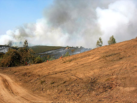
Wednesday, September 5. Work continued north of Blue Ridge on Bollinger Ridge and Divide Ridge to stop fire spread to the north. The major effort was spent in preparing Orestimba Creek Road and Red Creek for a huge backfire the next day. The fire, having crossed County Line Road in many places, backed down toward Orestimba and Red Creeks, sometimes driven by winds from the west. To the south, the fire flanked toward Willow Ridge, making moderate progress.
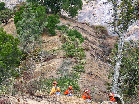
Firefighters seek rest and saftey in a bulldozed safety zone on Willow Ridge
Field crews noted the February, 2007 prescribed burn on Willow Ridge and used it as a control anchor for the southern boundary of the fire.
State Park fire employees from throughout California, averaging ten in number each day, began the process of mapping bulldozer lines and other fire suppression damage repair opportunities.
Thursday, September 6. Fifteen miles of backfiring were scheduled for the day. Two separate crews started at Dowdy ranch. One started north on the Kaiser Aetna Road with the ominous task of firing out both Orestimba Creek Road and Red Creek. The other headed east at the Scherrer Trail, Center Flats Road, and Willow Ridge.
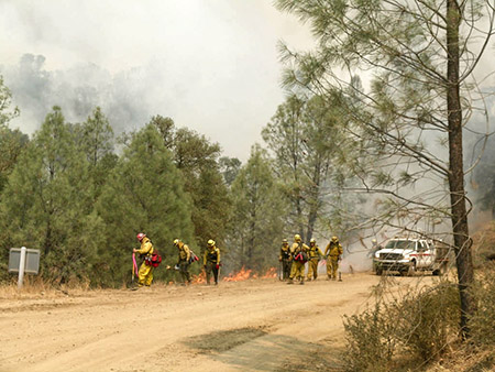
Crews backfiring along Kaiser Aetna Road
There were inevitable escapes from the backfire. Some occurred near the intersection of County Line Road and Kaiser Aetna Road, which were contained. However, in late afternoon, Ranger Cameron Bowers, observing from Paradise Flat, radioed in with the report of fire from the backfiring operation escaping into the heart of the Orestimba Wilderness toward Robison Mountain. A bulldozer headed up the hill to catch it, but was thwarted by steep terrain.
A view towards Robison Mt. — The bulldozer was unable to stop the fire on the ridge to the left of the scene.
This was a key moment in limiting suppression activity in the wilderness. Superintendent Mat Fuzie and I lobbied to let the fire burn through the entire northern acreage of the park. Had the crews been fresh, direct attack in the wilderness probably would have prevailed. But the decision was made to back off to the previous years' wildfire firelines on Mount States. This would add another 10,000 acres to the fire.
Due to heavy brush, terrain, and the risk of spotting, the backfiring along Scherrer Trail went slower than expected, only several miles of the 7 miles being completed.
Friday, September 7. Because the fire had escaped across the road, backfiring along Red Creek was abandoned. This day was spent holding Orestimba Creek Road, and preparing a fireline on Mount Stakes.
To the north of Blue Ridge, the fire was uncontained in several places due to steep terrain and heavy brush. Daily fire spread was slow here. This area would become the last to be contained by fireline, several days down the road. Willow Ridge backfiring was completed today. The southern fireline was in place and holding.
The ghostly ash shadow of a fallen oak on Orestimba Creek.
Saturday, September 8. Firing north past the Rooster Comb toward the intersection of Robison Creek and Orestimba Creek was completed and firing began on the Mount Stakes fireline. This was the third day of fire spread north from Paradise Flat, and the fire was making surprising slow progress. Apparently, the valley of Robison Creek slowed the spread of the fire. The backfiring was completed successfully, controlling the northern and eastern boundaries of the fire.
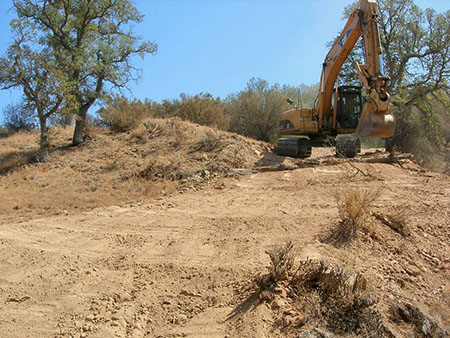
Two excavators (a rehabilitation rarity) were ordered to close opened roads and return bulldozed soil to its original location.
Sunday, September 9. Burnouts continued along northern County Line Road. Work continued on some unbuilt fireline north of Blue Ridge.
Fire suppression damage repair began in earnest. An excavator erased an old road which had been re-opened near Poverty Flat, and two crews raked out berms along Blue Ridge.
Monday, September 10. Rehabilitation work occurred throughout area. The second excavator arrived and smoothed bulldozer lines on the east side of the fire. Hand crews raked lines along Willow Ridge. The area north of Blue Ridge still resisted attempts to establish a control line.
Repairing fire suppression damage along Orestimba Creek.
Tuesday, September 11. Containment lines were completed around the fire, and release of equipment began. Repair of suppression damage continued for several days.
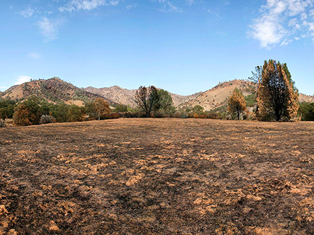
Nearly all persons who tour the fire have the impression that suppression damage to the park was minimal and/or the repair work did an adequate job of returning the park to a 'State Park' appearance.
Hand crews repair equipment damage along Eagle Pines Trail.
It can be said that, with 30 bulldozers working in the park for a week, more suppression activity occurred in a Unit of the State Park System in the Lick Incident than has ever occurred in California history. And from most accounts, it looks pretty good.
|